We are blessed in Illinois with an abundance of rivers, creeks, and streams that are navigable by canoe or kayak. Here in Pontiac, IL we have the Vermilion River running right through town, but it’s not the only stream in the area that’s good for canoeing and kayaking.
We have another little gem of a stream called Rook’s Creek. It is a tributary of the Vermilion River and just like the Vermilion, it flows from South to North.
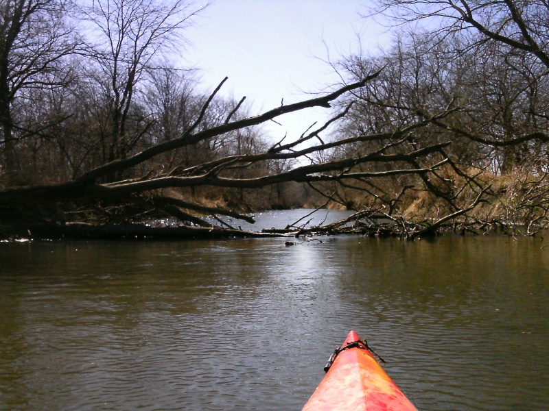
Rook’s Creek is just that, a Creek. It’s not a full fledged river. It’s small. It’s intimate. Most of the time the Creek is no more than 30 feet wide. Some people have described it as circuitous, which means that it’s twisty with lots of oxbows and curves to it.
Rook’s Creek is named for Roderick Rook, who was the first European settler in this part of Livingston County. Mr. Rook arrived in the Fall of 1830 or Spring of 1831. No one knows for sure. The creek and township still bare his name. This area has an interesting and colorful history. If you are curious, you can read more about Rook’s Creek History at this link.
Rook’s Creek is water dependent. The Creek is too shallow to paddle during a good part of an average year. That’s why this is one of my favorite places to paddle during the Spring after a day or two of good rain. There’s no river gage on Rook’s Creek, so catching it with enough water can be a bit of a gamble without local knowledge. As a rule of thumb, if the Vermilion is running medium to high, Rook’s Creek probably has a good water level, but there is no guarantee.
If you are lucky enough to catch Rook’s Creek with a good water level, and you like paddling twisty little creeks, you won’t be disappointed by this trip.
The Creek is navigable further upstream, and I have explored several miles of the Creek upstream of the suggested put-in for this section, but because of access limitations, parking availability, and trip length, this is the section that works best in my experience. If you can arrange for private access or want a longer trip, there are options to paddle several more miles of Rook’s Creek starting upstream from Rt. 116.
Trip Description
River Map: Google River Map with mile markers and access points
Trip Length: approximately 13.75 miles ( Route 116 to E 2400 N )
Shuttle Route: The shuttle route takes approximately 15 minutes each way.
Click this link for Google Map Shuttle Route Directions.
Water Level: Since there is no river gage on Rook’s Creek, about the only good way to know if there is a sufficient water level in the Creek is to go take a look at it. Since that may not be possible for anyone who lives more than a few miles from the Creek, looking at the Vermilion River Pontiac Gage is your next best bet. A reading of 3.5 feet or more on the Vermilion River Pontiac Gage would be the minimum amount that might indicate a good water level in Rook’s Creek to me. It’s always just a guessing game because there is no direct correlation between that gage reading and the water level in Rook’s Creek.
The nice thing is, if the Vermilion River Pontiac Gage has a reading of 3.5 feet or more you know that even if Rook’s Creek is too low, the Vermilion River has enough water to paddle. The Vermilion River is just a short drive away from Rook’s Creek.
Always err on the side of caution and use your best judgment. If the river or Creek looks too high, figure something else out. It’s better to find another place to paddle or go for a hike at Humiston Woods than to have an accident when the water is high.
Difficulty: Because of the swift currents, numerous riffles, and its narrow twisty nature, very good boat control and river ( Creek ) reading skills are needed to safely paddle this part of Rook’s Creek. It is NOT suggested for novice paddlers.
At lower water levels this is a very long trip. For that reason this trip is not suggested for novices, unless you can arrange alternate access points that shorten the trip.

Dangers: There are several notable dangers on this part of Rook’s Creek.
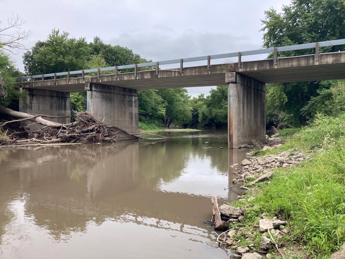
The first one is a farmer’s ford over Rook’s Creek. It is located at ( 40.92381, -88.74103 ). That’s about 7 river miles from the Route 116 bridge and about 4.25 miles from where Rook’s Creek meets the Vermilion River. This low water crossing in the creek can pose a danger at certain water levels. It can act like a lowhead dam and create a recirculating wave below the ford. An unsuspecting paddler could get caught in that current and easily be injured or drown. Please us extreme caution at this site.

The other area that merits mention is just before Rook’s Creek joins the Vermilion River. This is just after the Bayou Bluffs Campground.
The banks of the Creek are extremely narrow and steep in this area. Combined with some fairly sharp twists and turns, this area can pose a significant hazard to paddlers when deadfalls and/or strainers clog the stream. Approach this area with caution.
At lower water levels this part of the Creek can be an easy float for boaters with good skills. The higher the water level, the greater the risk and dangers will be. Always use use judgment, take proper precautions, and paddle within your abilities.
Put-In:
The Put-In for this trip is located at the Route 116 bridge over Rook’s Creek. This is near the former location of the Rook’s Creek Chapel, about 3 miles West of Pontiac, IL. The Chapel was torn down a few years ago, so now there is a nice gravel parking lot next to the Creek.
Other Put-In locations further upstream are possible, but I have found this location convenient and easy to find for people who live outside this area. It also makes the trip a more manageable distance, since we usually do it in the Spring when the daylight hours are still pretty short.
The Route 116 bridge over Rook’s Creek is currently being replaced, so care must be taken to not interfere with the construction crews and not trespass on their work site. Right now, as long as the construction crews are not working on the weekends, there isn’t much of a problem and the access from the parking lot is not too bad.


Take-Out:
The Take-Out location for this trip is the same as the Pontiac to Cornell Vermilion River trip. It’s at the E 2400 N Rd bridge over the Vermilion River. It’s about one mile West and one mile South from Cornell, IL.
Parking and access to the river can be obtained at the Northeast corner of the bridge. Please stay away from the property at Southeast corner of the bridge. That is a private access.

The one other significant feature along Rook’s Creek that I would like to mention is Bayou Bluffs campground. The campground is located at 9406 E 2350 N Rd. A few miles Southwest of Cornell, IL.
This is near the confluence of Rook’s Creek and the Vermilion River. If you want to combine camping with your paddling trip on Rook’s Creek, Bayou Bluffs is a no-brained. Taking-Out at Bayou Bluffs would also shorten this trip by about 3 miles, for a total of approximately 10.75 miles.
Be safe. Have fun.
“If you are serious about changing your life … you will find a way. If you are not … you will find an excuse.” – Unknown ( borrowed from Priscilla Croskey Blecha )
Previous Post: “Vermilion River – McDowell to Pontiac”
Next Post: “Wilderness Systems Backband Installation”

